Paul Ayers, attorney, SoCal historian, and Altadena hiking trail expert and restorer (Paul on Facebook, Paul’s channel on YouTube) has shared many remarkable location discoveries over the years, including the Little Tramp’s walking-away-alone finale spot from Charlie Chaplin’s The Circus (1928). I’m happy to host guest blogger Paul’s amazing post regarding the lost LA trolley history appearing in an early silent film. Take it away Paul.
+ + +
The first silent movie location puzzle I solved for John involved a railway scene. In his initial work, Silent Echoes, John actually asked his readers for help with a location, specifically, that of the motorcycle-meets-train segment from Keaton’s Sherlock Jr. I had a fairly extensive library of out-of-print train books, and in one, I found that the shot took place in Atwood, a Santa Fe whistlestop in northeast Orange County. (Read about The Circus walk-alone finale and the Sherlock Jr. stunt HERE).
Since that time I have identified a number of rail-related locations. These include the use of the Ontario Southern Pacific station in Harold Lloyd’s The Freshman, the Santa Fe line between Inglewood and Redondo beach in Buster Keaton’s The Goat and Lloyd’s An Eastern Westerner, the Hynes Union Pacific station in Lloyd’s Girl Shy, and the Southern Pacific’s Tropico station, also in Lloyd’s An Eastern Westerner. It is not uncommon that when John has a railroad problem to solve, he gives it to me to work on. The latest puzzle and the subject of this blog is the attempted suicide-by-streetcar from Lloyd’s 1920 two-reeler, Haunted Spooks.
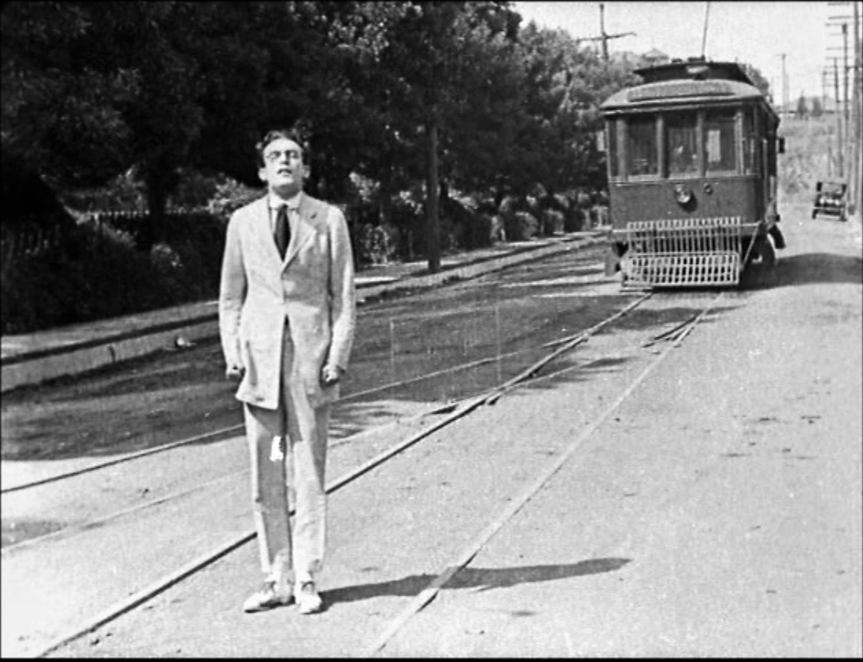
Beginning about nine minutes into the film, Lloyd learns that a girl he is infatuated with is being wooed by another man. Despondent he resolves to end his life. Happily he does not succeed but in his efforts to do so, laughs are generated.
One of the attempts involves standing in front of an oncoming streetcar; this plan is foiled when the car switches to a parallel track just before hitting him. It was the location of this scene that John asked me to identify.
Based on the locations that John had already identified, it was clear that the scene was shot in Los Angeles. Accordingly, it was a fair assumption that the shot utilized a line of one of the two streetcar companies operating in Los Angeles in the 1920s, the Los Angeles Railway [LARy] or the Pacific Electric [PE] Railway.
A primary difference between the two railways was their track gauge, which is the space between the rails. PE used standard gauge of 4’ 8 ½”, LARy used narrow gauge of 3’6”. It was apparent to me that the track seen in the footage was narrow gauge. As such, it was fairly certain that the car and track used in the scene belonged to LARy.


There were certain specific aspects of the setting which provided clues as to the scene’s location. Above, the track was laid in a single block with “T” intersections at both ends, and a slight incline.
 At the lower end of the block, above, a streetcar appears moving in the background. Looking in this direction, at frame right, a park-like open space lined with shrubbery is seen; here we see children observing the filming.
 Looking uphill beyond the street-side shrubbery, a bare road cut is seen, while above, buildings, with specific architectural elements, are visible.
 You can watch the brief scene on this non-official YouTube clip starting at 9:46.
In addition to these specific clues, one general rule guided my efforts. Silent movie scenes which involved trains or trolleys usually took place on little-used or abandoned routes; the simple reason for this was that the rail companies did not want heavily used lines to be disrupted by filming. The Santa Fe line from Inglewood to Redondo Beach provides a good example of this rule in action. Originally opened as a tourist line to Redondo, this role had been supplanted by direct PE lines to the beach city and by the late teens the line had become a seldom used freight line. This and its proximity to Hollywood, made it perfect for filming, and it was used by such diverse directors as Keaton [The Goat], Lloyd [An Eastern Westerner] and D.W. Griffith [Intolerance]. Mary Pickford filmed here as early as 1912 for A Beast at Bay – read more HERE.
There followed a three month period of trying to figure out where in the LARy system the subject trackage was. Many locations were reviewed and discarded because they did not match the specific elements discussed above. Books and maps were pored over, internet searches and views of locations undertaken, all to no avail. Ultimately the solution came, as it often does, by taking a look at a resource which seemed to have nothing to do with the problem.
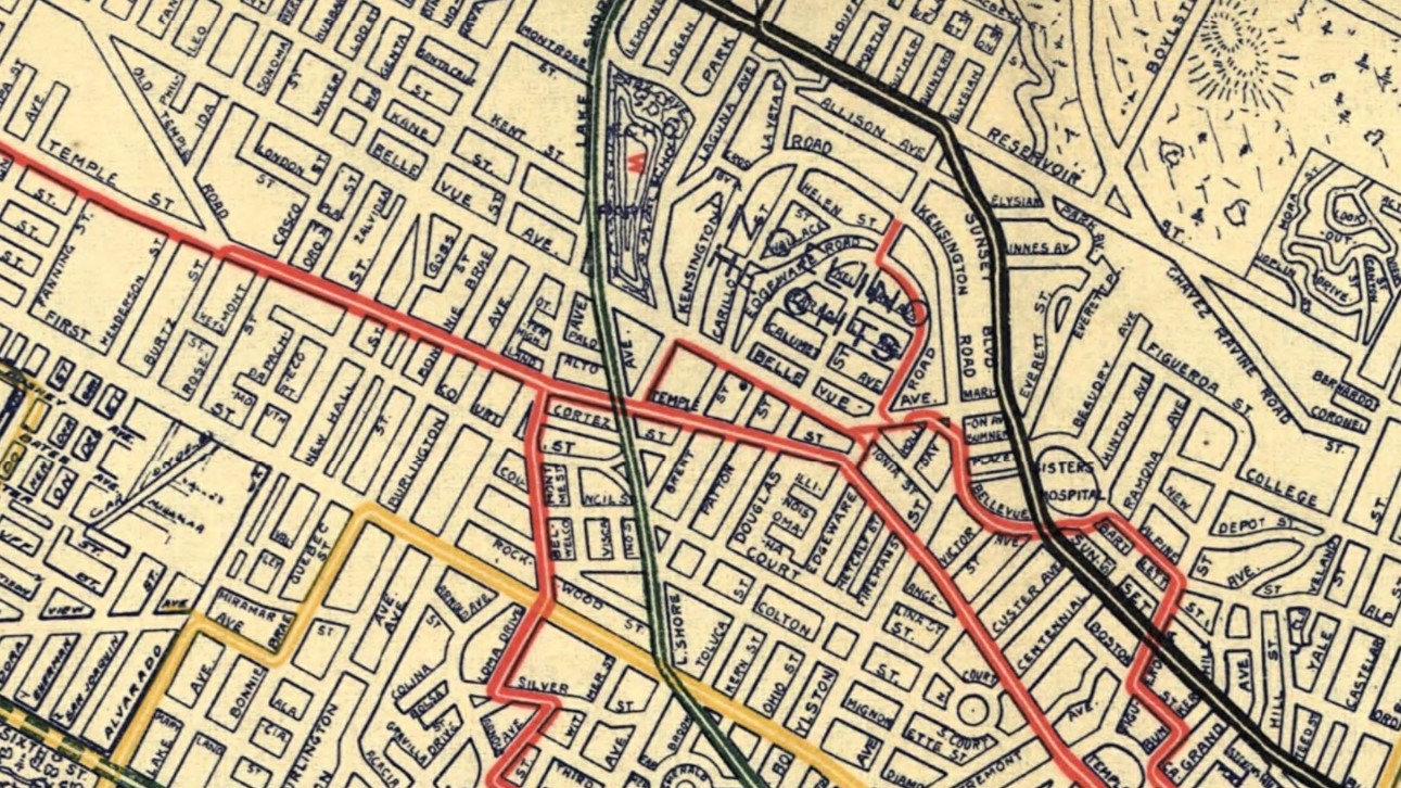
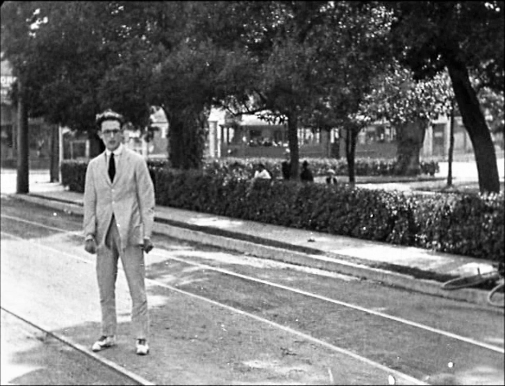
The standard research map for LARy lines is the 1938 route map; it did not reveal any trackage that satisfied the specifications of the scene. In taking another look at my rail maps I found a 1906 map (above) which I had not reviewed as feeling it too early to provide an answer to my problem. What it revealed was an extension to the LARy “C Line” which by 1938 had been abandoned, thus not on the 1938 route map. This extension ended on a single block run on what was then Echo Park Road (“the block”). The block had T intersections at either end; the southern intersection was with Temple Street, the northern with Bellevue Avenue.
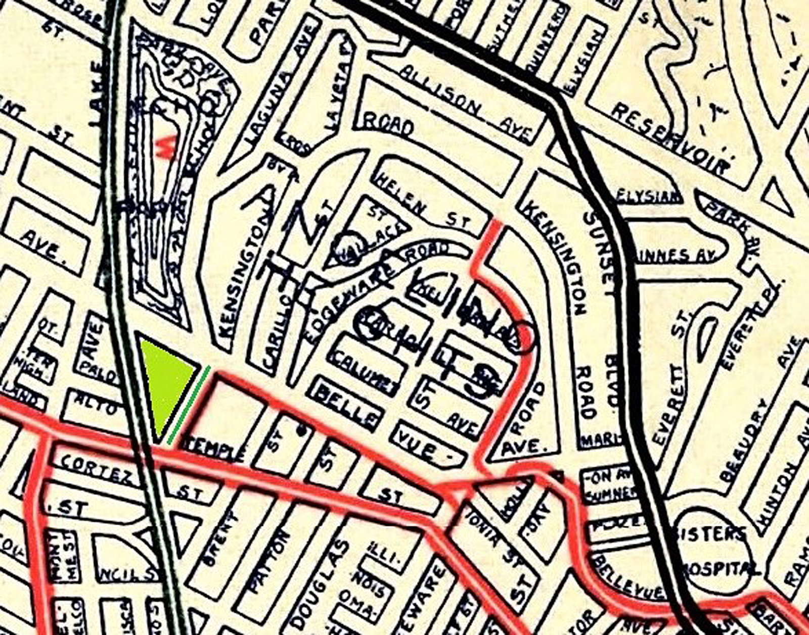 The discovery of the C Line extension quickly led to confirmation of the single block (green line above) as the sought location by additional proofs. Just west of the block between Temple and Bellevue was the Echo Park Playground (green triangle above), an open area that matched the park-like area shown in the frame with Harold and the children. Temple Street, which formed the south end of the block had a heavily traveled streetcar line. Looking in the other direction, a road cut seen in the film matched that on the north side of Bellevue; somewhat amazingly, the road cut survives to this day. Finally, building elements seen in the film, above the road cut, matched structures, some of which still survive, on Kensington Road, which intersects with Bellevue just to the east of the block.

A 1908 map of the same block (red line) where Harold filmed beside the Echo Park Playground.
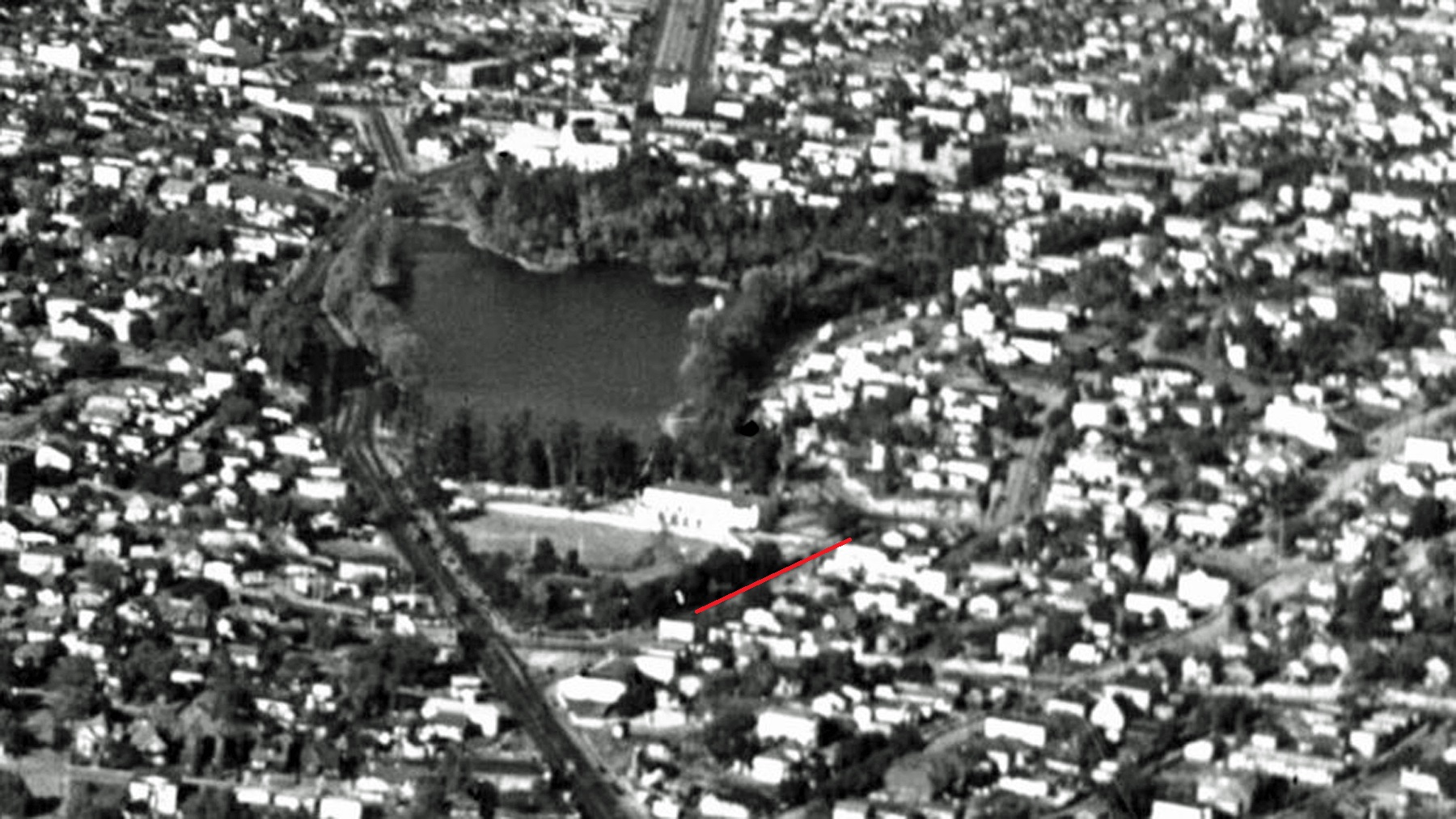
1938 view of Harold’s block (red line) on Echo Park Road – USC Digital Library

For context the north end of the Echo Park Playground and the prominent road cut along Bellevue at back. Harold stood far out of frame at right near the south end of the playground, with the road cut behind him and the playground to his left – Huntington Digital Library

Looking north – the extant home at 1128 W Kensington appears at back

1128 Kensington – matching 1920 view north and 1941 view east – c-7334_104 FrameFinder
In retrospect one of the challenges of finding the location was its absolute obliteration by the construction of the Hollywood Freeway in the 1950s; if Lloyd were standing in the same position as seen in the subject scene he might be dodging freeway traffic. Happily with the scene and the identification of its location we have a marvelous remembrance of a bygone Los Angeles.
+ + +
Thank you so much Paul for this amazing discovery. My book Silent Visions shows where Harold filmed other failed suicide scenes from Haunted Spooks at the Millbank Mansion at 3344 Country Club Drive, at Lincoln Park, and at Hollenbeck Park.
Below the scene location today – the stretch of Echo Park Road between Temple and Bellevue where Harold stood no longer exists.


Amazing. What else can I say?
LikeLiked by 1 person
The line as a cable railway had the powerhouse at Edgeware. After cessation of service, it then went over to Pacific Electric (or related) which later turned it over to Los Angeles Railway with the Great Merger of 1911. So, is the trolley in the Huntington Library 1909 era shot of the playground a P.E. car in the 100’s? If so, was there any trackage diagram before and after the LA Ry. conversion…it might be that this segment was a loop track which no longer served its’ original purposes as the line became re-routed to a stub end operation. (LA Ry operated this end as parts to different lines in various eras. The shift of East Hollywood services to a different routing still left this local line as the surviving portion of another downtown service. IIRC, that lasted to 1946-7 when the freeway destruction, er construction, began.) At any rate, great job Paul!
LikeLiked by 1 person
The foreground trolley in the 1909 photo is on Lake Shore Ave., now called Glendale Blvd. Is that relevant?
LikeLike
That would make more sense, such that the side destination boards would be read as “GLENDALE & S.P. DEPOT” covering the terminus points. That, of course, is a separate interurban line and not part of the original local line out Temple. If the “extension” line was derived from an older PE loop (not even sure of that yet), that would be walking distance to jump lines. [The question of transfers was always a big issue between PE and LA Ry. as part of the whole ownership fight between Huntington and the Harriman roads.]
LikeLiked by 1 person
Pulled it up as Line 42 on a 1908 transit map labeling it as the “Crown Hill Line” of Pacific Electric’s City Divisions. (The street names are given in the description and numbers superimposed over the drawn in lines.) PE ran the Temple Street operations from 1902 to 1910 per ERHA pages online, whence it became LA Ry. routings.
LikeLike
Great history and interest trace!
LikeLike