[UPDATE – this post reveals numerous Hollywood locations, but the One A.M. mystery has been solved!] Charlie Chaplin’s 1916 Mutual comedy short One A.M. was unique in many ways. Charlie plays a drunken bon-vivant, returning home after a night on the town. Except for a brief exterior scene with his taxi driver Albert Austin, Charlie plays the entire movie solo inside his home, with no plot beyond his inept attempts to put himself to bed.

Chaplin made the film at his small Lone Star Studio at Lillian Way and Eleanor, that would become Buster Keaton’s home studio four years later. The studio stood a short block south of the Santa Monica Blvd. trolley line. Because a trolley passes Charlie as he struggles exiting the taxi, I had long wondered if Charlie conveniently filmed the scene near his studio.

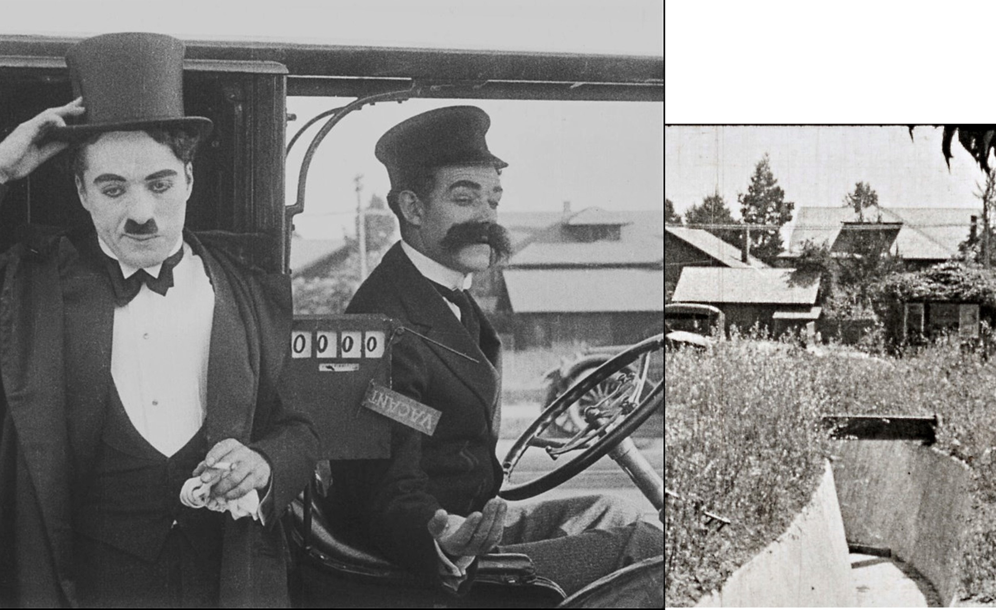
Click to enlarge – One A.M at left, note trolley tracks, matching homes from Waiting at the Church at right. Look closely, a vacant lot faces the trolley line in the near background. The small structures are garages facing an alley, and the homes further back face an adjacent street, not the trolley line street.
 Silent movies not only document the times in which they were made, they also provide clues for solving location mysteries from other films. Enter the comedy duo Lyons and Moran. (At left, the rear of a distinctive matching home from One A.M. and their Waiting at the Church.)

Working with the Library of Congress, silent film hero Michael Aus has made several early Lyons-Moran comedies (his eBay link) available to the public (sale proceeds benefit the Niles Essanay Silent Film Museum). In particular, his release Waiting at the Church (1919) (see post HERE) is one of the most visually consequential silent films I’ve ever seen, with scenes filmed all around early La Brea, Highland, and nascent Hollywood Boulevard. Comparing frames above, Waiting at the Church (bottom frame) clearly provides a broader view of Charlie’s taxi scene from One A.M. (top frame). Look at the matching details; the vacant lot, chimneys, small garages facing an alley, and distinctive roof lines.

But wider views from Waiting at the Church, presumably looking east, show a curved irrigation ditch running below the street with the trolley line, guarded by a metal safety railing (above) to protect people from falling into the ditch. Charlie must have exited his taxi near this railing.

Another matchup – One A.M. at top, Lyons and Moran at bottom, with vacant lots on both sides facing the trolley line.
I’ve studied the 1919 Sanborn fire insurance maps, the 1920 Baist Atlas, and numerous vintage aerial photos. The section of Santa Monica Blvd. near Chaplin’s Mutual Studio lacks a vacant lot with a setback alley and further offset homes. Likewise, tracking north-south along the Western Ave. trolley line doesn’t seem to match the details. My best guess is that Charlie and Lyons-Moran filmed along the north-south Highland Ave. trolley line, looking east, towards the vacant NE corner of Fountain and Highland (homes were never built on this corner, today the site of a strip mall), with an alley separating Highland from the adjacent block McCadden Place. As further “proof,” Lyons and Moran filmed other scenes from Waiting at the Church on this adjacent block of McCadden Place, just steps from the candidate corner.
Public Appeal – while the available clues seem consistent, there’s no definitive proof. The essential puzzle piece, the curved ditch (presumably running parallel along Fountain, then curving north, then east below Highland and the trolley line, then continuing eastward underground) remains elusive. Does anyone know or recognize this early Hollywood clue? Can someone please solve the Chaplin One A.M. mystery?

Click to enlarge – Waiting at the Church. At left, La Brea at Hollywood Blvd., with the Bernheimer Estate up the hill. At right, La Brea looking north towards Santa Monica Blvd., the Bernheimer Estate again at back. The Pickford-Fairbanks Studio on Santa Monica Blvd. stands off camera to the left in the right frame.
During Waiting at the Church Lyons and Moran run up and down La Brea Avenue, a few blocks north or south of Chaplin’s independent studio opened in 1918 at 1416 N. La Brea Ave., providing tantalizing glimpses of Charlie’s neighborhood.

Click to enlarge – Waiting at the Church, looking north up La Brea. The hilltop Bernheimer Estate at center stands directly above a side view of the large, white closed Chaplin Studio shooting stage (see below). Charlie’s corner office entrance stands directly behind the right motorcycle cop.

Side view of Chaplin Studio matching above movie frame from Waiting at the Church.

A final view from Waiting at the Church, looking north from the La Brea – Sunset Blvd. corner of the Chaplin Studio. The mansion on the studio grounds where Charlie’s half-brother Syd once lived stood on the SE corner of this intersection.
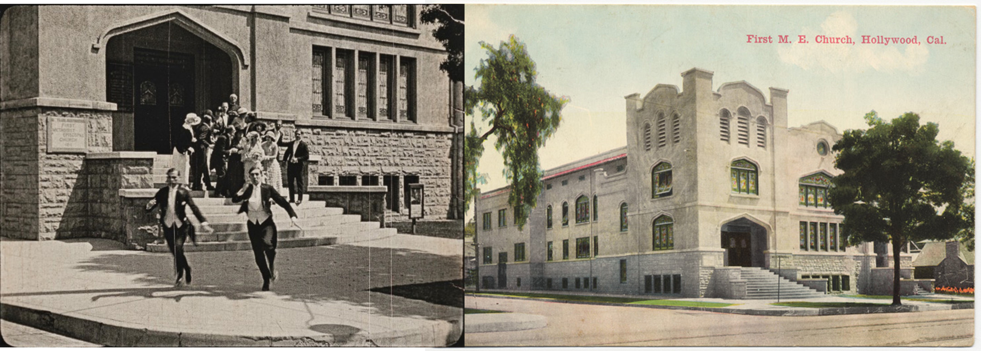
Please check my prior post about Waiting at the Church HERE. Above, Lyons and Moran flee the former First Methodist Episcopal Church on the corner of Hollywood and Ivar.

Another Lyons and Moran link with Charlie, they filmed What a Clue Will Do (1917) at 645 New High Street years before Charlie filmed The Kid (1921) at the same spot. Read more HERE.
Charlie’s studio on La Brea was once a lemon orchard. This YouTube video shows more of Charlie’s studio neighborhood.


Even after doing research on DeMille’s arrival, I am stunned by the verdant acres on Sunset. Thanks, Mark
LikeLiked by 1 person
John this is a magnificent bit of detecting. I can’t get enough.
Sent from my iPhone
>
LikeLiked by 1 person
Steve Martin:
“I’m not sure where this photo was taken but I have recently seen posts on Facebook which referred to a canal that ran from the LA River near Griffith Park to a reservoir that is now Echo Park lake. As I recall, the route of this canal ran through the Edendale neighborhood just west of Glendale Blvd near the sight if the Mack Sennett studios (an ideal location for the filming of the Chaplin feature)”
LikeLiked by 1 person
Thank you so much. This is very helpful. Hollywood at the time was agricultural (Charlie’s studio was built in a lemon orchard), so I can’t help but wonder if this was some orchard irrigation ditch.
LikeLike
I know the specifics of the route of the Canal and Reservoir Ditch (and the Main Supply and East Side Ditches) and I can’t think of a location that matches this view or where it crosses a rail line in this way. Also, the ditch was almost completely unlined and mostly out of service by 1911.
LikeLiked by 1 person
I’ve spent the last 4 hours scouring the official maps of Hollywood and Los Angeles, including storm drains, sewers, bridges, assessment districts, Pacific Electric and trolley car layouts. The only thing I have found is a partially constructed drainage channel paralleling Cahuenga, not Highland, at Fountain. The reason I mention it is that the shape of a portion of the channel is a similar profile to the one shown in the photos. Unfortunately, the layout doesn’t match the sinuous form or cross any street perpendicularly.
LikeLiked by 1 person
Thank you so much for looking into this. Charlie’s choice of location is so odd. The mundane background does not suggest the urban nightclub life, and why would he travel blocks or miles for such a generic shot when a comparable bland background was at his Mutual studio? Conceivably the two movies discussed here could depict different spots, but it seems highly unlikely. As mentioned, Lyons and Moran filmed other scenes on the adjacent block, and in 1919 there simply weren’t hundreds of other candidate corners. The roof details seem unique and a perfect match. Hollywood was only just beginning to bloom. The 1919 Sanborn map 1054 shows a “public ditch” starting at Selma and El Centro, continuing north up to Hollywood Blvd. The public ditch continues north on map 1024, across Hollywood Blvd. close and parallel to Gower. Would you be able to send an image of the Cahuenga drainage you found? Thank you once again – this is truly a mystery.
LikeLike
I looked at newspaper ads of the period mentioning ‘irrigation ditch’ but nothing turned up. This is a longshot but could the scene on the porch of the house have been filmed nearby? House number is 8711. Not sure how rare house numbers are in the 8700 range.
LikeLike
Pingback: Harold Lloyd’s “Hot Water” Sherlock turkey troubles | Chaplin-Keaton-Lloyd film locations (and more)
The relatively narrow unimproved road might seem to suggest the Sunset extension line or a view looking southward across Franklin near Bronson where there once was a bridge over an open stream bed that was probably channeled and subducted later on. However, there are clues here. The use of natural lighting would hint toward mid day shooting. (The motorcycle scene shadows suggest late day, and this may have been due to a need to close that street off.) So, we do see shadows suggesting the sun is largely right of the canal, and this would be on the south. Therefore, the canal must generally run east and west, placing the trolley line roadway running north-south. As it turns out, a shot looking westward on Sunset crossing Highland seems to indicate that the Avenue was rather narrow before the extension through Cahuenga Pass made it necessary to widen that roadway…bigger streetcars and more traffic. So I would suggest this is likely on Highland below Sunset and those dirt lots could have been cut into during road widening. The canal itself is too deep for a common irrigation ditch but may have once been a main inlet for the groves of the area. Doesn’t seem likely to be for flood control either. And the further down Highland toward Santa Monica, the more you run smack into a commercial/industrial sector with rail branches. I’d be searching further up. But I’m an idiot anyways.
LikeLiked by 1 person
Wow, thank you so much Al. I’ll have to wait to check this out, but your insights and observations are very exciting. I’ll post again once I can take a close look. Thanks again – John
LikeLike
Working with a bad photo from 1923, but I’m now leaning to the tree line left of Lyons and Moran is N. Formosa where it terminated at Santa Monica, across from where Pickford Studios went in. So this lot in the foreground would now be the site of the Formosa Cafe (ex-Red Post Cafe) with the gas tank built behind us in time. The frontage across the road would all be commercial development by 1932. Of course, this is a 7 year gap between images so I won’t guarantee it yet. But it is consistent with shooting near La Brea.
LikeLiked by 1 person